Courtesy Walton Arts Center
Art is not exclusively making. Sometimes, it’s about discovery, planning and a serendipitous walk.
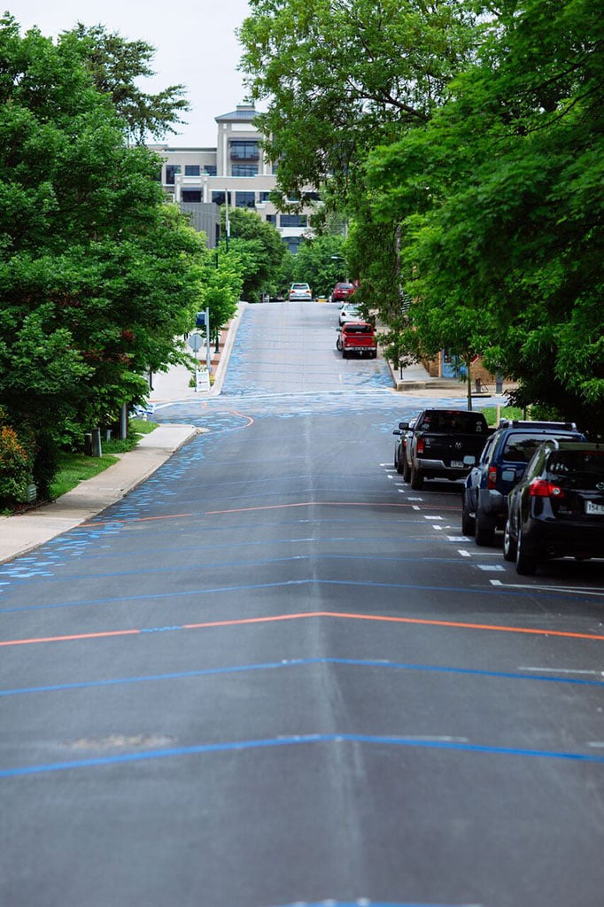
When installation artist Stacy Levy was in Fayetteville to work on her piece “Spiral Wetland,” which floated on Lake Fayetteville in 2013, there were many meetings required of her. She would often walk School Avenue in Fayetteville between the Walton Arts Center, the organization that commissioned the work, and the Fayetteville Public Library. And each time she did, she noticed the slope of the road nearly stole her breath.
“It was such a steep road … It was a really hot walk up to the library,” she recalls of that summer. But her inner artist was already working on it as a new problem. Five years, a few grants and a new commission later, her idea has been realized with “Topo Map for School Avenue.” Although the work has been installed for several weeks, the work officially debuts June 15 and coincides with the Walton Arts Center’s Artosphere Festival. The official opening event begins at 6:30 p.m. Friday, June 15 at the Bradberry Amphitheater and garden area at the Walton Arts Center. Fayetteville mayor Lioneld Jordan and Walton Arts Center CEO Peter Lane will be on hand for the event.
“Topo Map” continues in Levy’s style of highlighting the natural world that exists in urban spaces. She has spent her professional career creating commissioned pieces that focus on issues related to wind, rain, stream flow or plant growth. That’s much like her “Spiral Wetland” project, which curled away from the lake dam and included live plants to provide a home and food for fish and birds.
“I don’t do the kind of work that happens inside of four white walls,” she said.
Opening party for “Topo Map of School Avenue”
What: The official opening of the four-block-long art project will take place in between performances that are part of the WAC’s Artosphere Festival. A ribbon cutting will take place, along with remarks by WAC CEO Peter Lane and Fayetteville mayor Lioneld Jordan.
When: 6:30 p.m. June 15
Where: Bradberry Amphitheater and gardens, located on the east side of the Walton Arts Center in Fayetteville
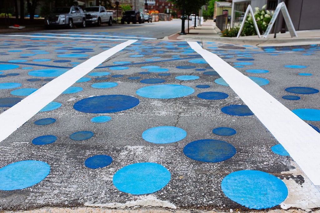
“Topo Map” makes the same voyage Levy did during her downtown walks. It covers four blocks of School Avenue with a precision-measured topographic map meant to show how water flows on the street. To show the water’s path, Levy said the piece works in two simultaneous parts. The topographic map uses a series of colored chevrons that cross the width of the street to denote the elevation and its changes. Like a traditional, printed topographic map, each five foot mark is set in a different color, in this case orange. The second part are the blue circles that dot the edges of the street. The circles represent where water pools during heavy rain events. Where a high concentration of the blue circles can be found is where more water would collect.
The lines on the ground are accurate, and the water circles are true-to-life as well, and Levy has done this on purpose to add an educational element.
“We really never think about the topography under our city,” she said.
The installation was conceptualized over more than two years, during which Levy also sought permissions and partners. Among the permissions she needed was the city of Fayetteville, which consented to shut down parts of School Avenue on and off for two weeks while crews affixed the thermoplastic stripes and circles with propane torches. One of her compromises was to change the color of the stripes. While many traditional topo maps have bright yellow stripes, those were not allowed in this setting because yellow marks on the road have a specific meaning.
“There is a very specific language of the roads,” Levy said. “I could not use white or yellow on the road. I would be misleading people.”
Levy worked with crews from the city of Fayetteville, Custom Pavement Maintenance and Safety of Van Buren and volunteers from Fenix Fayetteville to complete the installation of the project.
Now that the work is fully realized, Levy hopes those who walk on the street get a sense of the way water flows and how their own activities interact with the street.
“I really want people to get a sense of the [water flow]. There’s a living form underneath our grid,” she said.
“Topo Map for School Avenue” will remain on the street for an indefinite amount of time. Levy said the thermoplastic road materials typically last several years, but she and her artistic and city partners will assess how the work holds up as time advances in the event it deteriorates sooner than anticipated.