Armed with a day off from work and a hankering for some fresh air, an outing to the Buffalo River seems an obvious choice.
Skipping town from the east, follow the string of highways leading to Kingston, where you’ll cut through the downtown square to catch 74.
Highway 74 is a curlicue of a roadway, and with its curves and steep descents, there can be no mistake you’re entering the river valley. Heading north at the Highway 43 junction, Ponca, Arkansas soon crops up on either side of the road.
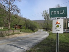
Entering Ponca
The town is a little more than an hour’s drive from Fayetteville and fits snuggly between the Buffalo River and the Ponca wilderness area to the east. The appeal, of course, isn’t necessarily the town itself, though the strip of highway within the city limits has its charm. Rather, Ponca is the prime location to start a float trip on what’s possibly the most scenic stretch of the Buffalo, or if you prefer, an all day hiking trip.
Aside from playing outdoors, there isn’t much to do in Ponca, unless of course you wanted to mail a letter. Ponca was settled as a mining town in the early 1900s, but when demand for zinc ore and lead declined after World War I, the town nestled into the country post it is now.
Putting in at the Ponca low-water bridge is a 10.6-mile float to Kyle’s Landing, which is just about perfect for a day trip. After a good rain this time of year, this stretch can be a swift ride, with a hasty current that can dictate how to approach the tumbling rapids ahead.
Not far into the float, Roark Bluff comes into view. The pronounced bluff with black and gray streaks running down its side extends for three-quarters of a mile, and it’s is one of the longest high cliffs outlining the Buffalo.
On down the river, Jim Bluff is marked by faded lettering dating back the 1960s. The unique bluff formation slightly juts out, providing shade for a shelf-like plateau beneath. The ledge then spills into the stream, a pool of calm blue-green water, great for swimming.
Floating down the river illustrates the Buffalo from one angle, but for the full effect, hiking along the bluff line and wilderness that frame the river introduces a greater perspective and more stunning scenes.
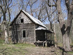
Granny’s Cabin
Consider the Center Point Trail. It starts about three miles north of Ponca on Highway 43, with the trailhead directly off the road. The trail is a steep hike, starting atop a hill and winding all the way down to the river’s edge. Sure, it’s an exhausting hike – 10.8 miles, roundtrip – but worthwhile. The path has access to Big Bluff, Granny Henderson’s house and is topped off with views of Hemmed in Hollow at the trail’s end.
The highlights of the trail begin about three miles into the hike where a small clearing emerges. While the proper trail continues slightly to the left, if you veer right, you can take a well-worn path called Goat’s Trail that leads to the edge of Big Bluff. Walking 300 feet above the river, the path is narrow and barely fits into the margin of the bluff’s overhang, providing little room for missteps. But while caution is essential, the detour presents a precipice endowed with impossibly beautiful views of the river.
Continuing on the main trail, the path plunges until you can hear the rush of water from the river. As it flattens out, the Henderson house can be reached within 100 yards of the trail.
Eva (Granny) Henderson gained a bit of fame when she was featured in a National Geographic article in 1977. Even as she aged into her 80s, Granny Henderson lived alone in this house and tended to her farm animals. She was one of the last people to live along this section of the river, even after 1972 when Congress declared the Buffalo a national river – the first river to acquire that distinction.
Inside the cabin, the walls are still lined with old newspapers, which served both as wallpaper and a way to keep the chill from coming in through the cracks. Though tattered, the papers still show their datelines from the 1920s.
From the cabin, the trail crosses Sneeds Creek, so find a shallow path for stepping stones, and get your feet wet.
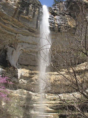
Hemmed in Hollow
About a mile and a half later, the trail ends, meeting its crescendo at Hemmed in Hollow. At a measured 204 feet, it is the tallest waterfall between the Appalachians and Rockies. After a hefty rain, the waterfall cascades like a faucet, and the stream sways in whichever direction the wind happens to be blowing. The waterfall is also accessible from the river by parking your canoe and hiking for less than a mile. Either way, it is not to be missed.
To be sure, Ponca isn’t the place to relish in a nightlife scene or sample fine cuisine. Rather, it’s the kind of town that punctuates the frivolity in all that. Ponca is just the sort of day trip that let’s you experience the life and beauty that envelops the hills of Arkansas and reminds the forgetful that we live in a beautiful area.
[If the slideshow doesn’t load, please visit the entire set at our Flickr page.]